• Car enthusiast? Join us on Cars Connected! iOS | Android | Desktop
  • Hint: Use a descriptive title for your new message
    If you're looking for help and want to draw people in who can assist you, use a descriptive subject title when posting your message. In other words, "I need help with my car" could be about anything and can easily be overlooked by people who can help. However, "I need help with my transmission" will draw interest from people who can help with a transmission specific issue. Be as descriptive as you can. Please also post in the appropriate forum. The "Lounge" is for introducing yourself. If you need help with your G70, please post in the G70 section - and so on... This message can be closed by clicking the X in the top right corner.

What are these blue dots and lines on Nav screen

Dixit

Hasn't posted much yet...
Joined
Dec 2, 2010
Messages
11
Reaction score
0
Points
0
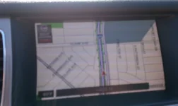
I had the Nav updated a few weeks ago after I saw the TSB where the 09s could have it done for free. Ever since then Ive noticed alot of the roads I drive on have these blue dots and lines on the roads but I dont understand what they are for.

They were not there before the update, cant seem to find anything searching around on what these mean. They are always blue, dont matter if its heavy traffic, 2am, not sure what they represent actually.

Dixit


They look like tracking dots to me. I haven't looked to verify, but I think there is a setting on the nav where you can mark (sort of like leaving bread crumbs) where you have been so that you can get back. I have seen this on a navigation system when used off road, so that you know how to get back. Just a hunch.
 
Moose is correct. It is tracking. Go in to the nav settings andvturn off tracking.
 
Thanks folks. That was it. Must have been enabled by default after the new update. Found that option and unchecked it. It was sort of bothering my wife cause she like "why the dots showing up on roads that Im not even on"

But guess now I know, it holds tracking I guess possibly forever or some extended period of time. Cause as I was unchecking the option I noticed if I bumped the knob to the right it gave an option to "Reset tracking" so it must be holding a good amount of it in memory.

Good deal and thanks for the info folks.

Dixit
 
Cookie crumbs. When the wife drives to the market every other night and you see that her path leads to her new found lover... you now no where to go and have someone check out for good!
 
Hahahah. That is one awesome way to look t it. Turn the tracking back on and see where she been and call her out!

Then I could end up on the couch if I'm wrong as well. Hahaha

Dixit
 
The dots only appear for the last so many miles, then drop off.

I like the tracking dots and leave them always turned on. I find it interesting to see where I have been. It has shown me that some of my frequent routes are longer than alternative routes.
 
Should stay for week or 2..mine does.
 
Check page 232 in the DIS user's manual (I've got a 2009 Genny).

"Position Tracking" will display the vehicle position for the past 124 miles (200 km). Resetting will delete the stored positions.
______________________________

Help support this site so it can continue supporting you!
 
From Dixit's "cookie crumbs" it looks like someone did some shopping at the Woodstock Shopping Center ;)
 

Attachments

  • MAP2.webp
    MAP2.webp
    49.4 KB · Views: 146
Well, you learn something new every day! I just turned this feature on - very interesting!
 
Looking to update and upgrade your Genesis luxury sport automobile? Look no further than right here in our own forum store - where orders are shipped immediately!
Yea I was wondering why the arrow was pooping out blue dots and I figured it out on my own...LoL....
 
Don't mean to hijack this thread but I have another question. Some roads, especially freeways, show sharp jagged edges on them usually in a green color. I thought they were freeway exits but they are not.

Does anybody know what they are? I have XM with traffic if that matters.
 
Don't mean to hijack this thread but I have another question. Some roads, especially freeways, show sharp jagged edges on them usually in a green color. I thought they were freeway exits but they are not.

Does anybody know what they are? I have XM with traffic if that matters.

If I understand correctly, I think you may be talking about parks that are in the green. I know at certain zoom heights lakes are parks are usually labeled with a name.

Are you thinking similar, or am I way off?:)

EDIT - I'm way the hell off
 
You currently have nav traffic... the green means no traffic issues...similarly the yellow and red indicate traffic problems... if you tap your dis you will see a screen pop up that will give you an option to see traffic problems, accidents, etc.
 
scottdk thanks for trying but it's not parks or lakes. It is actually road designation on the map. The line/road is a straight line (color coded according to how much traffic) and then there are jagged edges on it.

i thought it might designate freeway exits or no right turn or something similar but I don't think that's it. I'll try to get a screen shot of it but it's not easy to do while driving. Whatever it is I've thought about it and figure it out.
 
Here is a poor quality screenshot of the jagged green lines on my map. They may be freeway exits but I'm not certain. Does anybody know what they are?
 

Attachments

  • Zaggs.webp
    Zaggs.webp
    15.4 KB · Views: 115
Here is a poor quality screenshot of the jagged green lines on my map. They may be freeway exits but I'm not certain. Does anybody know what they are?

look at my posting above...its nav traffic
 
Back
Top